

Focus on Sonoma County
Scenarios
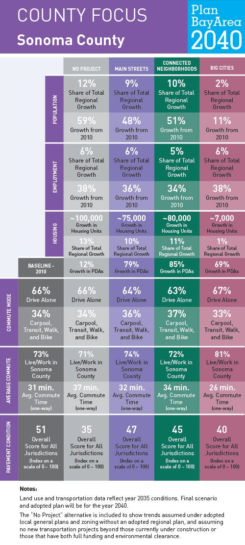
To help us understand where current and future Bay Area residents will live, work and get around in Sonoma County and beyond, planners at MTC and ABAG have generated forecasts for jobs, housing, population, travel demand and transportation revenue. To show how these forecasts might play out over time—and to ensure the Plan is meeting the goals Bay Area residents helped identify in 2015—planners have developed three scenarios. Understanding how these three planning scenarios will impact life in Sonoma County helps us recognize what issues may become most important as a preferred scenario is developed and Plan Bay Area updated.
Locally Adopted Priority Development Areas (PDAs) and Priority Conservation Areas (PCAs)
Sonoma County is the largest and northernmost county in the San Francisco Bay Area. The geographic makeup of the county is very diverse as it contains coastal areas, redwood forests and oak woodlands, rivers, wetlands and baylands, vineyards, grasslands, and small farms. Urban development in Sonoma County is concentrated primarily within cities along the U.S. 101 corridor, which has been supported by voter-approved urban growth boundaries and other policies that encourage separation between cities and scenic landscapes to maintain the county’s rural character and economy. Click the link to view three examples of the 12 locally adopted PDAs in Sonoma County.