

Focus on San Francisco County
Scenarios
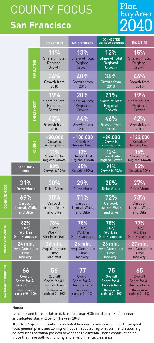
To help us understand where current and future Bay Area residents will live, work and get around in San Francisco County and beyond, planners at MTC and ABAG have generated forecasts for jobs, housing, population, travel demand and transportation revenue. To show how these forecasts might play out over time—and to ensure the Plan is meeting the goals Bay Area residents helped identify in 2015—planners have developed three scenarios. Understanding how these three planning scenarios will impact life in San Francisco County helps us recognize what issues may become most important as a preferred scenario is developed and Plan Bay Area updated.
Locally Adopted Priority Development Areas (PDAs) and Priority Conservation Areas (PCAs)
San Francisco is one of California’s largest cities and home to many of the region’s landmarks. Mostly surrounded by water, San Francisco’s population and employment growth over the decades was accommodated with more intense development throughout the city’s varied neighborhoods. As a result, the city has the highest residential and commercial densities in the region. San Francisco is one of the region’s largest employment hubs, and accommodates nearly one-half million commuters each day, many of whom travel using the region’s most extensive public transit system. Click on the link to view five examples of the 12 locally adopted PDAs in San Francisco.