

Focus on Solano County
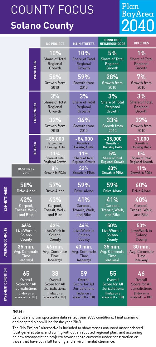
Scenarios
To help us understand where current and future Bay Area residents will live, work and get around in Solano County and beyond, planners at MTC and ABAG have generated forecasts for jobs, housing, population, travel demand and transportation revenue. To show how these forecasts might play out over time—and to ensure the Plan is meeting the goals Bay Area residents helped identify in 2015—planners have developed three scenarios. Understanding how these three planning scenarios will impact life in Solano County helps us recognize what issues may become most important as a preferred scenario is developed and Plan Bay Area updated.
Locally Adopted Priority Development Areas (PDAs) and Priority Conservation Areas (PCAs)
Solano County has the distinction of containing nearly one-half of the San Francisco Bay Area’s important farmland and more than one-half the region’s wetlands. The Sacramento River flows along the southeastern portion of Solano County, emptying into the Sacramento-San Joaquin River Delta – the largest estuary on the West Coast – and continues into the Suisun Bay. Solano County’s historical growth was in part attributable to military bases. With its location between the metropolitan centers of San Francisco and Sacramento and its lower land prices relative to other parts of the region, the county has been an attractive place for lower-cost housing development in recent decades. Click the link to view three examples of the 11 locally adopted PDAs in Solano County.